Lower Dolpo Trek - 28 Days

Lower Dolpo Trek

Trip Info

Trip Duration

28 Days

Max Altitude

Numala Pass 5,309 m

Difficulty

strenous

Start From

Kathmandu

Trip Ends At

Kathmandu

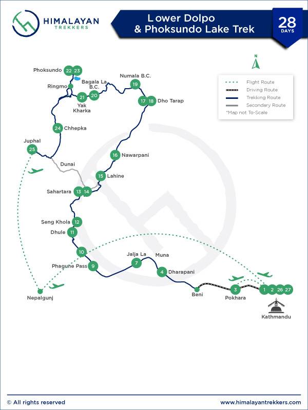
Lower Dolpo Trek Overview

Lower Dolpo, until a few years back, was very much untouched and least accessed not much seen by outsiders. Dolpo region is located towards the northern side of Nepal and is one of the most sought-after beautiful and pristine land on earth.

Lower Dolpo retains its centuries-old traditions and customs. The people of this region have managed to maintain their original lifestyles and it seems as if time has stopped ticking for them. There are no to few signs of modernity and one can feel the simplicity and the ingenuity of the population.

Also home to one of the oldest religious sects of Tibet, the Bon-Po which was practiced before Buddhism. It is an indigenous religion of Tibet believed to be founded by Tonpa Shenrab and was introduced to the Himalayas of Nepal when people from Tibet migrated to Dolpo.

This region is greatly influenced by Tibetan culture, this religious sect is still very active. If one is to believe the legends, then Dolpo is said to be one of the “Hidden Valleys” created by Guru Rinpoche as a refuge for devout Buddhists who would want to escape during adverse times.

Journey in Lower Dolpo Trek passes through fascinating forests of pine, oak, rhododendron, and juniper through the untouched isolated land pass. Our route also has a variety of exotic flowers - some main attractions on the trip.

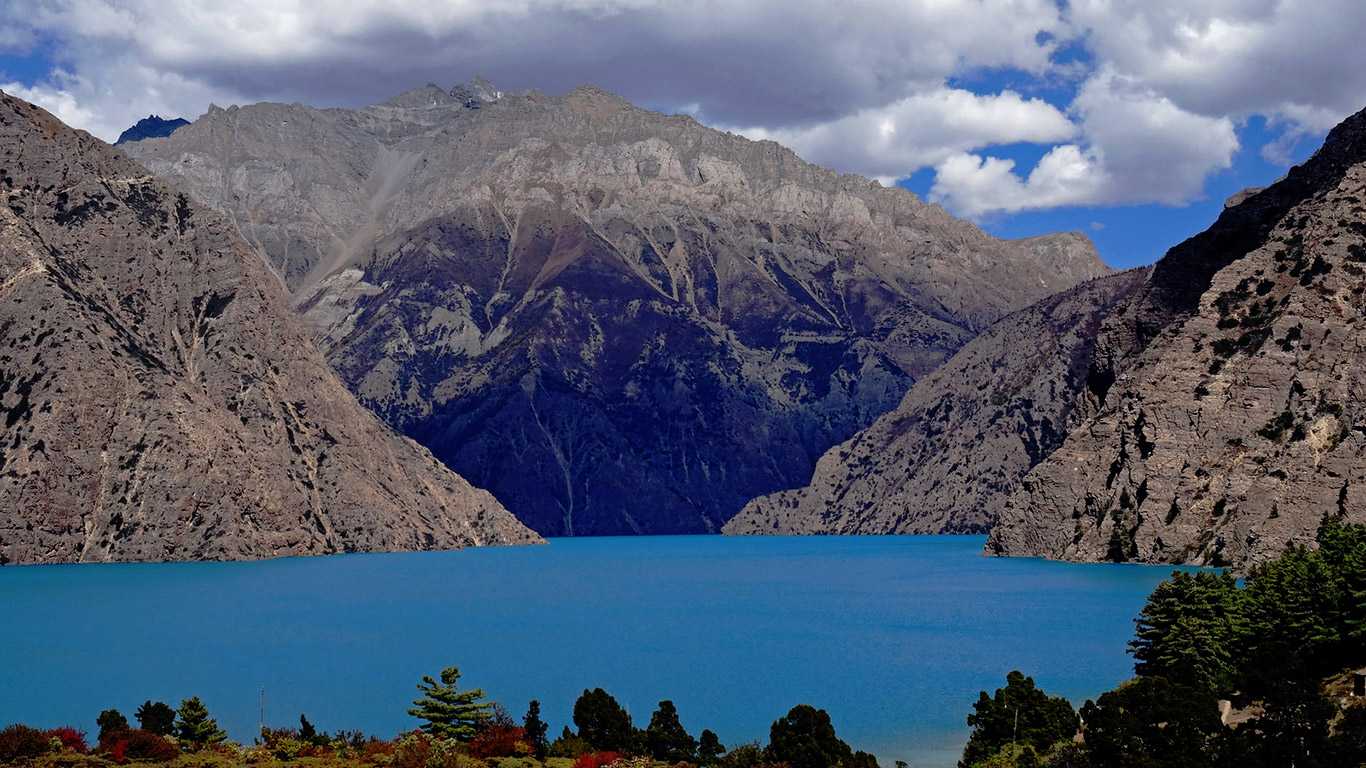
The mountain trails in this region are amazing and awe-inspiring, and the bodies of water are pristine and pure. On this trail, we will cross the Numala Pass at an altitude of 5,360 meters and also visit Lake Phoksundo, considered to be the brightest jewel of the Dolpo region.

The trip grade is strenuous and rugged but at the same time, it gives the trekker an experience to cherish. One is speechless with the abundance of natural beauty and the rich cultural experience Lower Dolpo Trek offers.

The trek starts at Beni and goes up to Phoksundo lake via Do Tarap and ends at Juphal where there is air connectivity. This is the same route that has been mentioned by Peter Matthiessen in his book “The Snow Leopard”. The trek is invariably described as a camping trek and is set up by Himalayan Trekkers' crew members. 

Trek Highlights

  • Walkthrough the ancient Trans-Himalayan Caravan route
  • Hike through the world deepest lake Shey-Phoksundo Lake
  • Least explored magical destinations
  • Walk past through charming forests of pine, oak, rhododendron, and juniper
  • Explore the “Jewel of Dolpo” - Phoksundo Lake


You might be interested in:

Upper Dolpo Trek 27 days.

Booking

  • Guaranteed Satisfaction
  • Transparent Price
  • No hidden fees
  • Experience of a More than two decade
  • Personal Touch & Professional Service

US$ 2,525 P/P


US$ 2,525.00

US$ 113.63

2,525

Quick Inquiry

Itinerary Details

Day 1: Arrival in Kathmandu
30 mins airport drive
Max Altitude: 1,400 m

Upon your arrival at the Tribhuwan International Airport (TIA) in Kathmandu, a representative from Himalayan Trekkers will greet you and transfer you to the designated hotel. We will be discussing the trek in detail and free time of your own. 

Meals: Dinner
Accommodation: 3 Star Hotel in KTM
Day 2: Kathmandu City Tour & Trek preparation
5-6 hrs
Max Altitude: 1,350 m

We will start our guided tour to several of the most historical and spiritual attractions and some of landmarks that are world heritage sites including the historic Kathmandu Durbar Square, the sacred Hindu temple - Pashupatinath, the famous 'Monkey Temple' (Swayambhunath), and Buddhists shrine (Boudhanath Stupa). 

In the afternoon, there will be a pre-trip discussion where we can meet our trek leader and other team members where we will discuss our trek

Meals: Breakfast
Accommodation: 3 Star Hotel in KTM
Day 3: Scenic flight/ drive to Pokhara
30 min flight or 6-7 hrs drive
Max Altitude: 827 m

Today either we fly to which will be 30 minutes scenic flight or you can 7 hours/200km drive to Pokhara. If the weather is clear you can see the Ganesh Himal, Langtang Lirung, Manaslu, and Annapurna as soon as you start going down from Kathmandu. 

In the evening, stroll around the lakeside, or depending on the time you reach Pokhara, we may opt for boating in the Phewa Lake. Pokhara is one of the most admired and most visited cities by foreigners after Kathmandu.

Meals: Breakfast
Accommodation: 3 Star Hotel in Pokhara
Day 4: Drive to Tatopani via Beni
4-5 hrs drive
Max Altitude: 1,190 m

The journey starts with a scenic drive in the morning. We drive uphill taking a winding road all the way to Naudanda. The road then descends to Nayapul. Along the way, you can have a panoramic view of Annapurna South, Machhapuchre, lush green hills, terraced fields, and villages. 

The drive offers one of the most picturesque terrains on the whole trip. We drive along the banks of the Myagdi River until we reach Beni. Beni (830m) is a large village situated on a plateau above the river. The trail to Dhorpatan and Dolpo starts at the southern end of Beni. 

We further drive following the river (Myagdi Khola), which starts from the Dhaulagiri glacier till reaching our overnight destination. The hot spring (Tatopani) along the way is one of the most notable places to see today. It is a great idea to take a dip and relax in the hot spring.

Meals: Breakfast, Lunch & Dinner
Accommodation: Guest House
Day 5: Trek to Ratodunga
5-6 hrs trek
Max Altitude: 1,050 m

We will cross the bridge of Myagdi Khola and climb up a rocky path dug into the cliff just over the river. The trail goes up and down through the village and forest. The majority of people in this area belong to the Magar, Chhetri, and few other ethnic communities. 

Meals: Breakfast, Lunch & Dinner
Accommodation: Tea house/ Tented camp
Day 6: Trek to Muna
6-7 hrs trek
Max Altitude: 1,700 m

We walk through a flat path passing the villages of Takum and Sibang. After Sibang, We approach a climb to ascend up to the small settlement known as Mattim. From here there is a crest which we descend and reach Muna.

Meals: Breakfast, Lunch & Dinner
Accommodation: Tea house/ Tented camp
Day 7: Trek to Jaljala Jangla
5-6 hrs trek
Max Altitude: 3,390 m

We take the trail from Muna to Jaljala La (3,390 m) via Lumsum (2,100 m) and Moreni (2,670 m). To reach Lumsum we make a steep climb, passing through oak and rhododendron forests with views of Himalayan peaks like Dhaulagiri, Mana Pathi and other unnamed peaks. 

As we are walking past the Moreni village we will see a glimpse of Tibetan lifestyle and culture as most people here have Tibetan roots. After Moreni, we will make a steep descent and reach the settlement at Jaljala Jangla.

An alpine settlement on top of a ridge, Jaljala is a vantage viewpoint. It is also used by the nearby villagers as pasture land for their cattle. Don’t be surprised if you see some Yaks and mountain goats along the way! 

This is a perfect camping area and the view of the Dhaulagiri range from this point is just breathtaking. Jangla La is the place from where the ancient kingdom of Tichrong, the valley of Fragrant water starts. Tichurong was a medieval kingdom that was administered from the then city of Tarakot or Taragaon or Dzong.

Meals: Breakfast, Lunch & Dinner
Accommodation: Tea house/ Tented camp
Day 8: Trek to Dhorpatan
6-7 hrs
Max Altitude: 2,870 m

Today we will trek from Jaljala La to Dhorpatan (2,870 m) via Gurjakot (3,070 m). The trails are vertically steep till Gurjakot and then it moves through flat land all the way to Dhorpatan. We walk along the banks of the river passing through the forests of oak, pine, rhododendron, juniper, and other local vegetation. 

Gurjakot is a small village, predominantly inhabited by people who follow the Tibetan culture. The trek gets more interesting as we walk past the chortens and Mani walls, which are symbolic of Tibetan Buddhism and the culture of the area. 

Dhorpatan, our campsite of the day lies at the junction of roads leading to the districts of Baglung, Beni, Rolpa, and Rukum. We can also see a small airstrip as we approach Dhorpatan. 

The place has apple orchards and you can also see terraced fields of wheat, buckwheat, maize, and potatoes. One of the most significant features of Dhorpatan Hunting Reserve is that anyone can go hunting by paying certain fees to the Government authority.

Meals: Breakfast, Lunch & Dinner
Accommodation: Tea house/ Tented camp
Day 9: Trek to Phagune Pass
6-7 hrs
Max Altitude: 4,061 m

Leaving Dhorpatan, we head uphill to Phagune Pass. On the way, we pass grasslands and sparse forests. Phagune Pass is surrounded by green hills and we can see the distant mountain top villages. 

Meals: Breakfast, Lunch & Dinner
Accommodation: Tea house/ Tented camp
Day 10: Trek to Pelma
6-7 hrs
Max Altitude: 2,400 m

Today we will follow a steep trail that goes down past some beautiful villages, terraced fields, and a suspension bridge over Pelma Khola (stream). As we cross the bridge we will make a gentle ascent up through terraces and local villages all the way to Takur. 

As we are heading towards Pelma we will cross the wooden bridge over the Pelma river and walk ahead. This part of the trail is most notable for the terraced farms and small settlements along the routes. Pelma is just another village like the many others dotting the hillside.

Meals: Breakfast, Lunch & Dinner
Accommodation: Tea house/ Tented camp
Day 11: Trek to Dhule
5-6 hrs
Max Altitude: 3,300 m

We will trek from Pelma to Dhule (3,300 m) crossing Yamakhar (2,480 m) and Gorba Khola (2,930 m). After crossing Pelma Khola the trail climbs steeply all the way to Dhule. 

As we are moving forward we come across a number of small villages and terraced farms and we also get an opportunity to peep at the daily lives of people here. We camp for the night at Dhule, a beautiful mountain village.

Meals: Breakfast, Lunch & Dinner
Accommodation: Tea house/ Tented camp
Day 12: Trek to Seng khola
5-6 hrs
Max Altitude: 4,000 m

Leaving Dhule we trek via Nautale Bhanjyang (3,961 m) to Seng Khola. This part of the trail goes past dense forest with vegetations such as rhododendron, pine, and juniper after which we reach the resting place at Nautale Bhanjyang. From here we can have magnificent views of Dhaulagiri ranges and the other Himalayan peaks.

Another 2 hours of climb and we reach our campsite for the day. The last quarter of the walk is steep and we might slow down a bit and take enough stops and rest along the way. There are terraced fields of wheat, buckwheat, and potatoes surrounding the village of Seng Khola, which is our campsite for the day! 

Meals: Breakfast, Lunch & Dinner
Accommodation: Tea house/ Tented camp
Day 13: Trek to Sahartara
7-8 hrs
Max Altitude: 2,730 m

We will trek from Seng Khola to Purpang (4,050 m) following a steep and rocky path. In route, we will come across alpine grasslands and the Panidal Pass located at an altitude of 4,412 m. From here we can have a magnificent view of the Dhaulagiri range, Kantagaton Himal, Nurbukang Himal, and some other unnamed peaks.

The trail leading to Purpang can be considered slippery as it is comprised of rocky terrain and involves a steep climb. Purpang is an open rocky grassland surrounded by magnificent mountains. From Purpang to Sahartara (2,730 m) the trail is steep passing through rocky terrain. From Jangla Bhanjyang (4,535 m) we get a panoramic view of Norbu Himal, Kantagaton, Dhaulagiri, and other Himalayan peaks. 

Crossing Jangla Bhanjyang (End of Dhorpatan Hunting Reserve area), we will follow a gently descending path all the way to Tokar, a small village surrounded by hills. After passing through some villages on our way down we at last reach Sahar Tara which is popular for the Yarchagumba harvesting trail.

Meals: Breakfast, Lunch & Dinner
Accommodation: Tea house/ Tented camp
Day 14: Leisure day at Sahartara
1-2 hrs hike
Max Altitude: 2,730 m

Sahartara is a small mountain village surrounded by terraced fields. The village boasts of a hot spring and today we can spend some leisurely hours bathing in the hot spring to ease our tired muscles.

Meals: Breakfast, Lunch & Dinner
Accommodation: Tea house/ Tented camp
Day 15: Trek to Lahini
6-7 hrs
Max Altitude: 3,370 m

From Sahartara we follow a trail along the banks of the river until we reach a large and green valley. Trekking forward from the village of Khani gaon to Lahini we have a chance of meeting the famous musk deer, bounding away in the midst of juniper and pine forest. 

Meals: Breakfast, Lunch & Dinner
Accommodation: Tea house/ Tented camp
Day 16: Trek to Nawarpani
7 hrs
Max Altitude: 3,780 m

From Lahini the trail becomes narrow and adventurous as we walk through areas that are prone to landslides and avalanches. We set up camp at Nawarpani which is situated in a grassy area.

Meals: Breakfast, Lunch & Dinner
Accommodation: Tea house/ Tented camp
Day 17: Trek to Dho Tarap
7-8 hrs
Max Altitude: 4,040 m

This day is one of the most significant milestones of this trek as it is a difficult and dangerous part of the trek. The valley narrows here. On this trail, we will approach some deep gorges and cross innumerable small bridges. 

We will follow a path that is carved out of a rocky cliffside. Following such an adventurous trail we will reach Dho Tarap.

Meals: Breakfast, Lunch & Dinner
Accommodation: Tea house/ Tented camp
Day 18: Acclimatization at Dho-Tarap
3-4 hrs
Max Altitude: 4,040 m

This day is dedicated for rest and acclimatization as we are approaching higher altitudes from now on. We will spend this day taking a short walk and hike around the village which has a notable number of chortens, Mani walls, and monasteries. 

The village also offers insight into the lifestyle of people living in the mountains, you will get an idea of how hard life is in these rocky areas, where you see people engaged in daily chores such as farming and cattle raising. 

Meals: Breakfast, Lunch & Dinner
Accommodation: Tea house/ Tented camp
Day 19: Trek to Numala Base Camp
4-5 hrs
Max Altitude: 4,440 m

After having a relaxed time and visiting all the gompas and Chorten in Tarap valley we take a trail that climbs up through grassy meadows filled with wildflowers to reach to Numala base camp. From the base camp, we get a beautiful view of the distant Tibetan mountains and the upper Tarap valley.

Meals: Breakfast, Lunch & Dinner
Accommodation: Tea house/ Tented camp
Day 20: Ascend Numala Pass & Trek to Bagala Base Camp (Pelungthang)
7-8 hrs
Max Altitude: 5,309 m

Today we will be crossing the Numala Pass and descend towards Poyon Khola till we reach the Bagala Base Camp (4,465 m) which is surrounded by big glaciers and blade-shaped rock cliffs. We stop for the night at Pelungtang, a village surrounded by hills that has temporary houses, yak pastures, and terraces. 

From this point, you have your first glimpse of Topo Peak (4,900 m). The Norbu Kang Himal sparkles brightly in the background.

Meals: Breakfast, Lunch & Dinner
Accommodation: Tea house/ Tented camp
Day 21: Ascend to Baga La Pass & Trek to Yak Kharka
6-7 hrs
Max Altitude: 5,169 m

We make our way to Yak Kharka via Bagala Pass. The top of the pass is a great vantage point as we can see the massive Kanjiroba Massif from here. After Baga La, the trails turn gently down all the way to Yak Kharka. Yak Kharka literally means the-grazing place of Yaks in the local language.

Meals: Breakfast, Lunch & Dinner
Accommodation: Tea house/ Tented camp
Day 22: Trek to Phoksundo Lake via Ringmo village
4-5 hrs
Max Altitude: 3,641 m

The trek to Phoksundo Lake (3,600 m) via Ringmo village (3,641 m) takes about seven hours. Ringmo is a small village predominantly inhabited by the Gurung and Thakuri communities. 

We will move along the flat land passing through pine forests, grassland, terraces, hills, and villages. After some time, Phoksundo Lake appears before you in all its glory. Before we reach the final destination of the day, we have to cross a bridge made of wood, resembling wooden bridges of medieval Europe.

Phoksundo Lake is the deepest lake of Nepal and also the deepest lake found at such a great altitude in the world. The big village on the banks of this lake is quite rich culturally. 

This area will help you understand more of Tibetan Buddhist culture and its practices that are unique to the mountainous regions of Nepal and some parts of Tibet, as you will visit small chortens and monasteries.

Meals: Breakfast, Lunch & Dinner
Accommodation: Tea house/ Tented camp
Day 23: Leisure day at Phoksundo Lake
3-4 hrs
Max Altitude: 3,600 m

Today we explore the area around the magnificent Phoksundo Lake. The lake is most notable for its green color resembling that of turquoise. Ringmo village, which looks like a typical Tibetan village, is scenically nestled in the folds of this area.

It is also home to many beautiful glaciers found near and above the lake area. There are many monasteries (Gompas) and Bon-Po religious sites and we can spend our time visiting some of these. 

Shey Gompa one of the oldest in all the Himalayan region is believed to date back to the 11th century. Thashung Gompa, one of the popular Gompa located near Phoksundo Lake was built about 900 years ago.

Meals: Breakfast, Lunch & Dinner
Accommodation: Tea house/ Tented camp
Day 24: Trek to Chhapka
7 hrs
Max Altitude: 2,378 m

After an interesting visit to the beautiful sights of the area, we leave Phoksundo and make our way towards Chhepka. From here on, we start descending down through the Sulighat River gorge.

First, four hours of the trail is steep and difficult to walk also like the trail is rocky and not well maintained. On the way, we pass Gurung and Tibetan villages surrounded by beautiful fields.

Meals: Breakfast, Lunch & Dinner
Accommodation: Tea house/ Tented camp
Day 25: Trek to Juphal
4-5 hrs
Max Altitude: 2,475 m

Trek from Juphal takes about five hours. We trek along a gentle climb until we reach Raktang. On the way, we will come across forests covered by pine, oak, juniper, rhododendron, bamboo and other natural vegetation that is also rich in wildlife. 

After leaving Raktang, we go down steeply and steadily for a few hours till our trail moves on flat land. En route, we cross several terraced fields, villages rich in Highland culture, check posts, and grasslands at Sulighat. 

We can also visit Dunai, the headquarters of Dolpo (time permitting). This little town has quite a large settlement and plenty of tea houses and a few government offices. We trek slightly flat land for a few more hours to reach Juphal, our final stop where the trek ends.

Meals: Breakfast, Lunch & Dinner
Accommodation: Trek Lodge
Day 26: Fly to Nepalguni & Connecting flight to Kathmandu
1 & 1/2 hrs flight
Max Altitude: 1,400 m

Today we have one and a half hour scenic flight from Julpa-Nepalgunj- Kathmandu. Since we have different flight schedules so we need to stay some time at Nepalgunj airport for the connecting flight to Kathmandu. We will reach Kathmandu in the afternoon. Free time of your own.

Meals: Breakfast
Accommodation: 3 Star Hotel in KTM
Day 27: Leisure day (optional)
3-4 hrs
Max Altitude: 1,400 m

You can use your free time by visiting some of the heritage sites of Kathmandu valley or you can do last minutes souvenir shopping from Nepal with your friends, families, and relatives. In the evening, joining the Himalayan trekkers' team for a farewell dinner with a cultural program.

(Note: Since Juphal lies in the mountainous zone and if we have a weather issue or other technical problems and we do not have a flight on the previous day then we can use this day to fly Kathmandu or if everything goes on our schedule then we can use this day as leisure day).

Meals: Breakfast, Dinner
Accommodation: 3 Star Hotel in KTM
Day 28: Departure from Kathmandu
30 mins airport drive
Max Altitude: 1,400 m

You can depart from Kathmandu to your home country or extend the trip and head for another trip within or outside Nepal.

Meals: Breakfast

What is included / not included

Include

  • TIMS
  • Permit
  • Airport pick-up and drop-off
  • Transportation as per the itinerary 
  • Guide and Porter
  • Meals (Breakfast, Lunch, and Dinner with Tea) during the trek/as per the itinerary
  • 3 Star hotel accommodation in Kathmandu
  • Best avilable accommodation during the trek
  • First-Aid Kit
  • Welcome/Farewell Dinner
  • All applicable government taxes and official expenses

Exclude

  • International airfares and airport tax
  • Nepal Visa fees
  • Trekking Equipment
  • Personal expenses such as laundry, liquor, room service, and others
  • Beverage expenses
  • Tips to Guide, Porter, and Driver
  • Travel Insurance
  • Any cost occurs from any unfavorable condition such as landslide, bad weather, flight cancellation, etc.
  • Anything not mentioned in the includes section

Accommodation

Himalayan Trekkers promise to manage the best, most comfortable, and preferred accommodation.

In general, we arrange a 3* Standard Category Accommodations with all facilities in cities. If available, you can opt for a more budget-friendly option or upgrade to a more luxurious hotel by paying a little extra.

Although all places during your trek do not have all modern facilities (especially at higher altitudes), we ensure that it is arranged safely and comfortably. Mostly hygienic and safe tea houses / local lodges/homestays are arranged & please feel free to personalize according to your preference.

If your travel schedule includes camping or if you choose to experience it, a correct campsite will be determined in advance and everything will be taken care of. If required, we also provide equipment such as a tent, cookware, etc. Check the equipment lists and equipment lists for more information.

Meals

Breakfast is usually included with your accommodation within the costs. Meals in the city must be paid separately. Often in the cities, you can choose from many different cuisines and varied food services. We can always help you find the right place.

Remote areas don't have that many options, but hygienic and well-prepared food is always served. Moreover, most meals are included in the costs during your trek. We can help you make changes according to your preference and budget, but only if choices are available! Moreover, Himalayan Trekkers also organize Welcome of Farewell Dinners as a symbol of warm greetings.

Follow the detailed route description or itinerary for more information. We are always there to help you to your heart's content.

© 2024 Himalayan Trekkers. All rights reserved.